


20170916-carolles PM

doudet
User
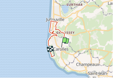

Length
8.2 km

Max alt
65 m

Uphill gradient
151 m
Km-Effort
10.2 km

Min alt
0 m

Downhill gradient
146 m
Boucle
No
Creation date :
2019-07-02 06:33:26.993
Updated on :
2019-07-02 06:33:26.993
--
Difficulty : Unknown

FREE GPS app for hiking
 SityTrail
IGN / Geographical institutes
SityTrail Plus
The world is yours!
About
Trail Walking of 8.2 km to be discovered at Normandy, Manche, Carolles. This trail is proposed by doudet.
Positioning
Country:
France
Region :
Normandy
Department/Province :
Manche
Municipality :
Carolles
Location:
Unknown
Start:(Dec)
Start:(UTM)
605929 ; 5400743 (30U) N.
Comments