


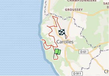
20170917-carolles lude A-M

doudet
User

Length
6.2 km

Max alt
73 m

Uphill gradient
118 m
Km-Effort
7.8 km

Min alt
6 m

Downhill gradient
125 m
Boucle
No
Creation date :
2019-07-02 06:33:29.319
Updated on :
2019-07-02 06:33:29.319
--
Difficulty : Unknown

FREE GPS app for hiking
 SityTrail
IGN / Geographical institutes
SityTrail Plus
The world is yours!
About
Trail Walking of 6.2 km to be discovered at Normandy, Manche, Carolles. This trail is proposed by doudet.
Positioning
Country:
France
Region :
Normandy
Department/Province :
Manche
Municipality :
Carolles
Location:
Unknown
Start:(Dec)
Start:(UTM)
605416 ; 5399923 (30U) N.
Comments