acquigny rando gps.net

doudet
User
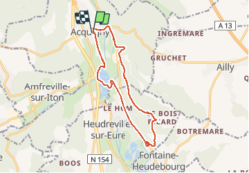

Length
13.4 km

Max alt
153 m

Uphill gradient
189 m
Km-Effort
15.9 km

Min alt
14 m

Downhill gradient
189 m
Boucle
Yes
Creation date :
2019-07-02 06:33:33.327
Updated on :
2019-07-02 06:33:33.327
--
Difficulty : Unknown

FREE GPS app for hiking
 SityTrail
IGN / Geographical institutes
SityTrail Plus
The world is yours!
About
Trail Walking of 13.4 km to be discovered at Normandy, Eure, Acquigny. This trail is proposed by doudet.
Positioning
Country:
France
Region :
Normandy
Department/Province :
Eure
Municipality :
Acquigny
Location:
Unknown
Start:(Dec)
Start:(UTM)
367330 ; 5448136 (31U) N.
Comments