


20151208-les damps

doudet
User

Length
13.8 km

Max alt
89 m

Uphill gradient
150 m
Km-Effort
15.8 km

Min alt
2 m

Downhill gradient
149 m
Boucle
Yes
Creation date :
2019-07-02 06:39:55.227
Updated on :
2022-10-13 06:18:26.01
3h25
Difficulty : Difficult

FREE GPS app for hiking
 SityTrail
IGN / Geographical institutes
SityTrail Plus
The world is yours!
About
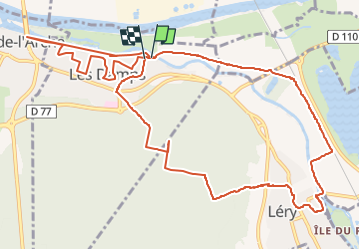
Trail Walking of 13.8 km to be discovered at Normandy, Eure, Les Damps. This trail is proposed by doudet.
Description
Boucle A-R au départ du Parking du Pont de Pont de L'Arche
Positioning
Country:
France
Region :
Normandy
Department/Province :
Eure
Municipality :
Les Damps
Location:
Unknown
Start:(Dec)
Start:(UTM)
367724 ; 5462742 (31U) N.
Comments