


st malo circuit samedi

doudet
User
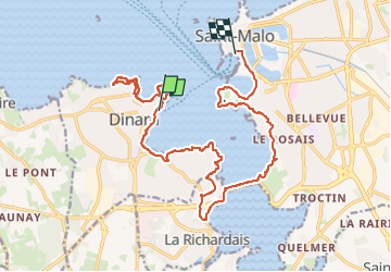

Length
19.8 km

Max alt
38 m

Uphill gradient
311 m
Km-Effort
24 km

Min alt
0 m

Downhill gradient
324 m
Boucle
No
Creation date :
2019-07-02 06:51:10.305
Updated on :
2019-07-02 06:51:10.305
--
Difficulty : Unknown

FREE GPS app for hiking
 SityTrail
IGN / Geographical institutes
SityTrail Plus
The world is yours!
About
Trail Walking of 19.8 km to be discovered at Brittany, Ille-et-Vilaine, Dinard. This trail is proposed by doudet.
Positioning
Country:
France
Region :
Brittany
Department/Province :
Ille-et-Vilaine
Municipality :
Dinard
Location:
Unknown
Start:(Dec)
Start:(UTM)
569996 ; 5387189 (30U) N.
Comments