


cormeilles

doudet
User
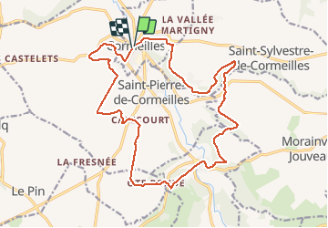

Length
19.4 km

Max alt
156 m

Uphill gradient
440 m
Km-Effort
25 km

Min alt
65 m

Downhill gradient
443 m
Boucle
Yes
Creation date :
2019-07-02 07:01:40.38
Updated on :
2019-07-02 07:01:40.38
--
Difficulty : Unknown

FREE GPS app for hiking
 SityTrail
IGN / Geographical institutes
SityTrail Plus
The world is yours!
About
Trail Walking of 19.4 km to be discovered at Normandy, Eure, Cormeilles. This trail is proposed by doudet.
Positioning
Country:
France
Region :
Normandy
Department/Province :
Eure
Municipality :
Cormeilles
Location:
Unknown
Start:(Dec)
Start:(UTM)
309091 ; 5458286 (31U) N.
Comments