


20170124-Stade_des_Violettes_

doudet
User
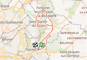

Length
14 km

Max alt
162 m

Uphill gradient
354 m
Km-Effort
18.7 km

Min alt
36 m

Downhill gradient
355 m
Boucle
Yes
Creation date :
2019-07-02 07:36:52.567
Updated on :
2019-07-02 07:36:52.567
--
Difficulty : Unknown

FREE GPS app for hiking
 SityTrail
IGN / Geographical institutes
SityTrail Plus
The world is yours!
About
Trail Walking of 14 km to be discovered at Normandy, Seine-Maritime, Darnétal. This trail is proposed by doudet.
Positioning
Country:
France
Region :
Normandy
Department/Province :
Seine-Maritime
Municipality :
Darnétal
Location:
Unknown
Start:(Dec)
Start:(UTM)
366702 ; 5478470 (31U) N.
Comments