


lac de blanchemer

ja.13061965
User
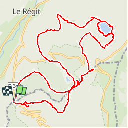

Length
16.2 km

Max alt
1171 m

Uphill gradient
539 m
Km-Effort
23 km

Min alt
965 m

Downhill gradient
540 m
Boucle
Yes
Creation date :
2019-06-20 09:33:17.55
Updated on :
2019-06-20 09:33:19.053
5h17
Difficulty : Easy

FREE GPS app for hiking
 SityTrail
IGN / Geographical institutes
SityTrail Plus
The world is yours!
About
Trail Walking of 16.2 km to be discovered at Grand Est, Haut-Rhin, Wildenstein. This trail is proposed by ja.13061965.
Description
Longue....
Positioning
Country:
France
Region :
Grand Est
Department/Province :
Haut-Rhin
Municipality :
Wildenstein
Location:
Unknown
Start:(Dec)
Start:(UTM)
346765 ; 5318386 (32U) N.
Comments