


GTDV J3

PhilippeC54
User
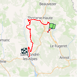

Length
44 km

Max alt
1679 m

Uphill gradient
1233 m
Km-Effort
62 km

Min alt
896 m

Downhill gradient
1744 m
Boucle
No
Creation date :
2019-07-02 06:38:04.014
Updated on :
2019-07-02 16:42:45.069
6h38
Difficulty : Difficult

FREE GPS app for hiking
 SityTrail
IGN / Geographical institutes
SityTrail Plus
The world is yours!
About
Trail Mountain bike of 44 km to be discovered at Provence-Alpes-Côte d'Azur, Alpes-de-Haute-Provence, Thorame-Haute. This trail is proposed by PhilippeC54.
Positioning
Country:
France
Region :
Provence-Alpes-Côte d'Azur
Department/Province :
Alpes-de-Haute-Provence
Municipality :
Thorame-Haute
Location:
Unknown
Start:(Dec)
Start:(UTM)
307192 ; 4879902 (32T) N.
Comments