


2013-06-05_082056

doudet
User
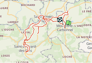

Length
25 km

Max alt
224 m

Uphill gradient
585 m
Km-Effort
32 km

Min alt
102 m

Downhill gradient
591 m
Boucle
No
Creation date :
2019-07-02 16:59:26.631
Updated on :
2019-07-02 16:59:26.631
--
Difficulty : Unknown

FREE GPS app for hiking
 SityTrail
IGN / Geographical institutes
SityTrail Plus
The world is yours!
About
Trail Walking of 25 km to be discovered at Pays de la Loire, Sarthe, Moulins-le-Carbonnel. This trail is proposed by doudet.
Positioning
Country:
France
Region :
Pays de la Loire
Department/Province :
Sarthe
Municipality :
Moulins-le-Carbonnel
Location:
Unknown
Start:(Dec)
Start:(UTM)
720388 ; 5361795 (30U) N.
Comments