


2011-04-05-02

doudet
User
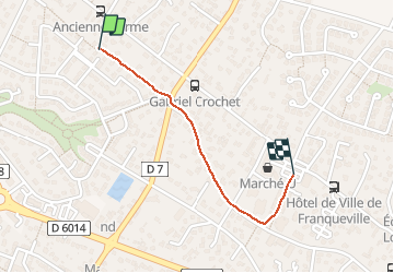

Length
885 m

Max alt
159 m

Uphill gradient
2 m
Km-Effort
935 m

Min alt
148 m

Downhill gradient
9 m
Boucle
No
Creation date :
2019-07-02 17:09:22.606
Updated on :
2019-07-02 17:09:22.606
--
Difficulty : Unknown

FREE GPS app for hiking
 SityTrail
IGN / Geographical institutes
SityTrail Plus
The world is yours!
About
Trail Walking of 885 m to be discovered at Normandy, Seine-Maritime, Franqueville-Saint-Pierre. This trail is proposed by doudet.
Positioning
Country:
France
Region :
Normandy
Department/Province :
Seine-Maritime
Municipality :
Franqueville-Saint-Pierre
Location:
Unknown
Start:(Dec)
Start:(UTM)
366852 ; 5474248 (31U) N.
Comments