


vienne osmonerie mayeras

pjoly
User
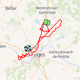

Length
153 km

Max alt
664 m

Uphill gradient
3149 m
Km-Effort
195 km

Min alt
191 m

Downhill gradient
3264 m
Boucle
No
Creation date :
2019-06-26 06:22:40.622
Updated on :
2019-07-03 09:03:03.065
26h49
Difficulty : Very easy

FREE GPS app for hiking
 SityTrail
IGN / Geographical institutes
SityTrail Plus
The world is yours!
About
Trail Mountain bike of 153 km to be discovered at New Aquitaine, Haute-Vienne, Saint-Sylvestre. This trail is proposed by pjoly.
Positioning
Country:
France
Region :
New Aquitaine
Department/Province :
Haute-Vienne
Municipality :
Saint-Sylvestre
Location:
Unknown
Start:(Dec)
Start:(UTM)
370649 ; 5094148 (31T) N.
Comments