


Rochepradiere-Douhady

Gegetop
User
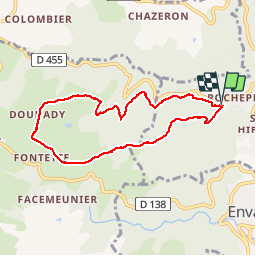

Length
7.3 km

Max alt
739 m

Uphill gradient
244 m
Km-Effort
10.5 km

Min alt
514 m

Downhill gradient
240 m
Boucle
Yes
Creation date :
2019-06-26 06:16:00.554
Updated on :
2019-07-03 14:55:11.964
1h45
Difficulty : Easy

FREE GPS app for hiking
 SityTrail
IGN / Geographical institutes
SityTrail Plus
The world is yours!
About
Trail Nordic walking of 7.3 km to be discovered at Auvergne-Rhône-Alpes, Puy-de-Dôme, Châtel-Guyon. This trail is proposed by Gegetop.
Description
En boucle
Positioning
Country:
France
Region :
Auvergne-Rhône-Alpes
Department/Province :
Puy-de-Dôme
Municipality :
Châtel-Guyon
Location:
Unknown
Start:(Dec)
Start:(UTM)
503563 ; 5084363 (31T) N.
Comments