


Île bygdog

cmar
User
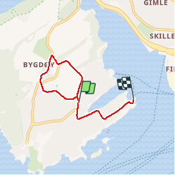

Length
3.4 km

Max alt
43 m

Uphill gradient
29 m
Km-Effort
3.9 km

Min alt
4 m

Downhill gradient
51 m
Boucle
No
Creation date :
2019-07-04 14:34:40.0
Updated on :
2019-07-04 15:32:59.348
58m
Difficulty : Unknown

FREE GPS app for hiking
 SityTrail
IGN / Geographical institutes
SityTrail Plus
The world is yours!
About
Trail Walking of 3.4 km to be discovered at Oslo, Unknown, Unknown. This trail is proposed by cmar.
Positioning
Country:
Norway
Region :
Oslo
Department/Province :
Unknown
Municipality :
Unknown
Location:
Frogner
Start:(Dec)
Start:(UTM)
594368 ; 6641889 (32V) N.
Comments