


Thise

TRIMAILLE
User
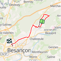

Length
18.1 km

Max alt
455 m

Uphill gradient
353 m
Km-Effort
23 km

Min alt
262 m

Downhill gradient
344 m
Boucle
No
Creation date :
2019-07-04 16:02:56.686
Updated on :
2019-07-04 18:48:01.393
2h43
Difficulty : Very easy

FREE GPS app for hiking
 SityTrail
IGN / Geographical institutes
SityTrail Plus
The world is yours!
About
Trail Walking of 18.1 km to be discovered at Bourgogne-Franche-Comté, Doubs, Thise. This trail is proposed by TRIMAILLE.
Positioning
Country:
France
Region :
Bourgogne-Franche-Comté
Department/Province :
Doubs
Municipality :
Thise
Location:
Unknown
Start:(Dec)
Start:(UTM)
279350 ; 5240873 (32T) N.
Comments