


leroj73
User
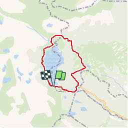

Length
11 km

Max alt
2226 m

Uphill gradient
388 m
Km-Effort
16.1 km

Min alt
1936 m

Downhill gradient
386 m
Boucle
Yes
Creation date :
2019-07-04 20:47:42.861
Updated on :
2019-07-04 20:47:42.861

FREE GPS app for hiking
 SityTrail
IGN / Geographical institutes
SityTrail Plus
The world is yours!
About
Trail of 11 km to be discovered at Occitania, Pyrénées-Orientales, Angoustrine-Villeneuve-des-Escaldes. This trail is proposed by leroj73.
Positioning
Country:
France
Region :
Occitania
Department/Province :
Pyrénées-Orientales
Municipality :
Angoustrine-Villeneuve-des-Escaldes
Location:
Unknown
Start:(Dec)
Start:(UTM)
417966 ; 4712369 (31T) N.
Comments