


steenwerk

jeanluc59
User

Length
12.7 km

Max alt
21 m

Uphill gradient
45 m
Km-Effort
13.3 km

Min alt
13 m

Downhill gradient
44 m
Boucle
Yes
Creation date :
2019-07-05 07:18:10.916
Updated on :
2019-07-05 11:14:19.647
3h54
Difficulty : Very easy

FREE GPS app for hiking
 SityTrail
IGN / Geographical institutes
SityTrail Plus
The world is yours!
About
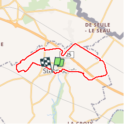
Trail Walking of 12.7 km to be discovered at Hauts-de-France, Nord, Steenwerck. This trail is proposed by jeanluc59.
Positioning
Country:
France
Region :
Hauts-de-France
Department/Province :
Nord
Municipality :
Steenwerck
Location:
Unknown
Start:(Dec)
Start:(UTM)
483835 ; 5616461 (31U) N.
Comments