


traverser de la tranche Verdon

nouga
User
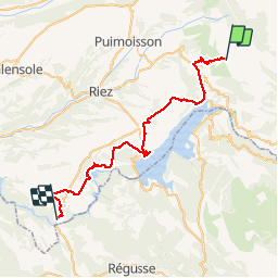

Length
46 km

Max alt
956 m

Uphill gradient
793 m
Km-Effort
58 km

Min alt
365 m

Downhill gradient
1370 m
Boucle
No
Creation date :
2019-07-05 06:48:12.817
Updated on :
2019-07-05 15:41:53.107
8h14
Difficulty : Very easy

FREE GPS app for hiking
 SityTrail
IGN / Geographical institutes
SityTrail Plus
The world is yours!
About
Trail Mountain bike of 46 km to be discovered at Provence-Alpes-Côte d'Azur, Alpes-de-Haute-Provence, Moustiers-Sainte-Marie. This trail is proposed by nouga.
Description
très belle randonnée sur 40 degrés de température
Positioning
Country:
France
Region :
Provence-Alpes-Côte d'Azur
Department/Province :
Alpes-de-Haute-Provence
Municipality :
Moustiers-Sainte-Marie
Location:
Unknown
Start:(Dec)
Start:(UTM)
279092 ; 4858403 (32T) N.
Comments