


SityTrail - Boucle Etang de Médecourbe-Port de Bouet- Etang de Soucarrane- Etang de Roumazet

c.chehere
User

Length
14.2 km

Max alt
2158 m

Uphill gradient
1439 m
Km-Effort
33 km

Min alt
927 m

Downhill gradient
1442 m
Boucle
Yes
Creation date :
2019-07-08 10:07:12.517
Updated on :
2019-07-08 10:35:25.634
6h30
Difficulty : Very difficult

FREE GPS app for hiking
 SityTrail
IGN / Geographical institutes
SityTrail Plus
The world is yours!
About
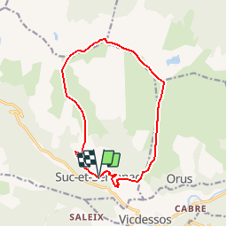
Trail Walking of 14.2 km to be discovered at Occitania, Ariège, Val-de-Sos. This trail is proposed by c.chehere.
Description
Se garer sur le parking à l'entrée de Suc
Positioning
Country:
France
Region :
Occitania
Department/Province :
Ariège
Municipality :
Val-de-Sos
Location:
Unknown
Start:(Dec)
Start:(UTM)
375404 ; 4737723 (31T) N.
Comments