


canoë Scouts 2018

albert318
User
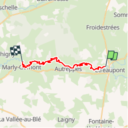

Length
17.7 km

Max alt
128 m

Uphill gradient
84 m
Km-Effort
18.9 km

Min alt
110 m

Downhill gradient
93 m
Boucle
No
Creation date :
2019-07-08 10:01:31.136
Updated on :
2019-07-08 16:47:28.777
6h42
Difficulty : Very easy

FREE GPS app for hiking
 SityTrail
IGN / Geographical institutes
SityTrail Plus
The world is yours!
About
Trail Canoe - kayak of 17.7 km to be discovered at Hauts-de-France, Aisne, Étréaupont. This trail is proposed by albert318.
Positioning
Country:
France
Region :
Hauts-de-France
Department/Province :
Aisne
Municipality :
Étréaupont
Location:
Unknown
Start:(Dec)
Start:(UTM)
565200 ; 5528551 (31U) N.
Comments