


les Goulots

Gegetop
User
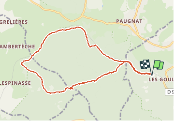

Length
10.2 km

Max alt
912 m

Uphill gradient
150 m
Km-Effort
12.2 km

Min alt
782 m

Downhill gradient
151 m
Boucle
Yes
Creation date :
2019-07-04 06:36:30.146
Updated on :
2019-07-11 07:27:18.738
1h54
Difficulty : Easy

FREE GPS app for hiking
 SityTrail
IGN / Geographical institutes
SityTrail Plus
The world is yours!
About
Trail Nordic walking of 10.2 km to be discovered at Auvergne-Rhône-Alpes, Puy-de-Dôme, Volvic. This trail is proposed by Gegetop.
Positioning
Country:
France
Region :
Auvergne-Rhône-Alpes
Department/Province :
Puy-de-Dôme
Municipality :
Volvic
Location:
Unknown
Start:(Dec)
Start:(UTM)
499225 ; 5079850 (31T) N.
Comments