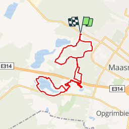
Trail Walking Maasmechelen - Maasmechelen - Photo
 flip96
flip96

User

© OpenStreetMap contributors
Length
Length
17.2 km
Max alt
Max alt
101 m
Uphill gradient
Uphill gradient
173 m
Km-Effort
Km-Effort  
19.5 km
Min alt
Min alt
48 m
Downhill gradient
Downhill gradient
173 m
Boucle
Boucle
Yes
Creation date :
2014-12-10 00:00:00.0
Updated on :
2014-12-10 00:00:00.0

(0 Reviews)

Walking
Walking
4h20
Difficulty : Easy

Scan this QR Code to open this trail in the SityTrail application

FREE GPS app for hiking

Logo SityTrail SityTrail

IGN / Geographical institutes

Download SityTrail from the App Store Download SityTrail from Google Play

Logo SityTrail SityTrail Plus

The world is yours!

Download SityTrail from the App Store Download SityTrail from Google Play Download SityTrail on Huawei AppGallery

About

Trail Walking of 17.2 km to be discovered at Flanders, Limburg, Maasmechelen. This trail is proposed by flip96.

Description

Rondwandeling op de Mechelse Heide. Vanuit Maasmechelen, Poort Nationale Park K5 (Joseph Smeetslaan 280 Maasmechelen).
Mooie, eenvoudige wandeling met in augustus/september bloeiende heide.
Prachtige waterplassen in voormalige zandgroeve.
Opmerkingen? flip96@home.nl

Elevation profile

Positioning

Country:
Belgium
Region :
Flanders
Department/Province :
Limburg
Municipality :
Maasmechelen
Location:
Mechelen-aan-de-Maas
Start:(UTM)
686663 ; 5650755 (31U) N.


Close
My subscriptions