


Col du Béal

ramsay
User
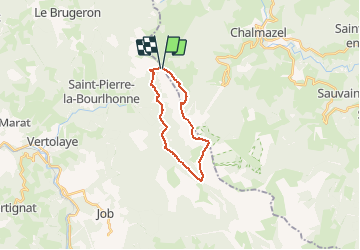

Length
16.6 km

Max alt
1609 m

Uphill gradient
556 m
Km-Effort
24 km

Min alt
1178 m

Downhill gradient
557 m
Boucle
Yes
Creation date :
2014-12-10 00:00:00.0
Updated on :
2014-12-10 00:00:00.0
5h03
Difficulty : Difficult

FREE GPS app for hiking
 SityTrail
IGN / Geographical institutes
SityTrail Plus
The world is yours!
About
Trail Walking of 16.6 km to be discovered at Auvergne-Rhône-Alpes, Loire, Chalmazel-Jeansagnière. This trail is proposed by ramsay.
Positioning
Country:
France
Region :
Auvergne-Rhône-Alpes
Department/Province :
Loire
Municipality :
Chalmazel-Jeansagnière
Location:
Chalmazel
Start:(Dec)
Start:(UTM)
561093 ; 5059393 (31T) N.
Comments