


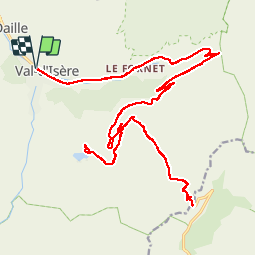
Col de l'Iseran

franquen
User

Length
36 km

Max alt
2762 m

Uphill gradient
1093 m
Km-Effort
51 km

Min alt
1822 m

Downhill gradient
1093 m
Boucle
Yes
Creation date :
2019-07-12 07:19:54.619
Updated on :
2019-07-25 15:36:06.408
5h42
Difficulty : Medium

FREE GPS app for hiking
 SityTrail
IGN / Geographical institutes
SityTrail Plus
The world is yours!
About
Trail Mountain bike of 36 km to be discovered at Auvergne-Rhône-Alpes, Savoy, Val-d'Isère. This trail is proposed by franquen.
Description
Partant de Val D'Isère une belle montée de 12 km. Ne pas oublier la doudoune pour descendre !
excellent resto à 4 km à la redescente au lac de l'Ouillotte (1km de ch de terre)
Positioning
Country:
France
Region :
Auvergne-Rhône-Alpes
Department/Province :
Savoy
Municipality :
Val-d'Isère
Location:
Unknown
Start:(Dec)
Start:(UTM)
341787 ; 5034976 (32T) N.
Comments