


Tredaniel - Montcontour

nolsim
User
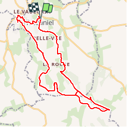

Length
20 km

Max alt
345 m

Uphill gradient
442 m
Km-Effort
26 km

Min alt
111 m

Downhill gradient
445 m
Boucle
Yes
Creation date :
2019-07-12 07:37:06.818
Updated on :
2019-07-12 14:00:56.21
5h12
Difficulty : Medium

FREE GPS app for hiking
 SityTrail
IGN / Geographical institutes
SityTrail Plus
The world is yours!
About
Trail Walking of 20 km to be discovered at Brittany, Côtes-d'Armor, Trédaniel. This trail is proposed by nolsim.
Photos


Positioning
Country:
France
Region :
Brittany
Department/Province :
Côtes-d'Armor
Municipality :
Trédaniel
Location:
Unknown
Start:(Dec)
Start:(UTM)
528272 ; 5356382 (30U) N.
Comments
belle rando !