


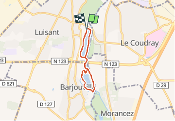
Tours des etangs , chartres 14/7/19

Robertplessier
User

Length
10 km

Max alt
136 m

Uphill gradient
44 m
Km-Effort
10.6 km

Min alt
126 m

Downhill gradient
47 m
Boucle
Yes
Creation date :
2019-07-14 10:12:23.029
Updated on :
2022-11-08 11:14:50.825
54m
Difficulty : Very easy

FREE GPS app for hiking
 SityTrail
IGN / Geographical institutes
SityTrail Plus
The world is yours!
About
Trail Running of 10 km to be discovered at Centre-Loire Valley, Eure-et-Loir, Luisant. This trail is proposed by Robertplessier.
Positioning
Country:
France
Region :
Centre-Loire Valley
Department/Province :
Eure-et-Loir
Municipality :
Luisant
Location:
Unknown
Start:(Dec)
Start:(UTM)
387734 ; 5364498 (31U) N.
Comments