


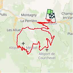
Boucle du col de la Loze

franquen
User


4h18
Difficulty : Medium

FREE GPS app for hiking
 SityTrail
IGN / Geographical institutes
SityTrail Plus
The world is yours!
About
Trail Electric bike of 56 km to be discovered at Auvergne-Rhône-Alpes, Savoy, Bozel. This trail is proposed by franquen.
Description
départ de Villemartin/Bozel et montée sur Courchevel pour prendre la nouvelle route du col de la Loze. Plongée su Meribel puis la Tania et retour sur Courchevel.
des pentes très raides avant le col et une descente aussi très raide.
Positioning
Comments