


gpx-trace Manerbe

jchezlemas
User
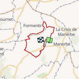

Length
10.1 km

Max alt
149 m

Uphill gradient
227 m
Km-Effort
13.1 km

Min alt
67 m

Downhill gradient
227 m
Boucle
Yes
Creation date :
2019-07-14 16:23:53.579
Updated on :
2019-08-02 15:56:39.456
2h48
Difficulty : Difficult

FREE GPS app for hiking
 SityTrail
IGN / Geographical institutes
SityTrail Plus
The world is yours!
About
Trail Walking of 10.1 km to be discovered at Normandy, Calvados, Manerbe. This trail is proposed by jchezlemas.
Description
Rando de Sylvie
https://www.randogps.net/randonnee-pedestre-gps-calvados-14.php?num=9&meta=MANERBE
et après repas au pot d'étain
http://www.restaurant-lepotdetain.fr/
Positioning
Country:
France
Region :
Normandy
Department/Province :
Calvados
Municipality :
Manerbe
Location:
Unknown
Start:(Dec)
Start:(UTM)
292755 ; 5451692 (31U) N.
Comments