


Tour du Plateau de Beille

maupassant38
User
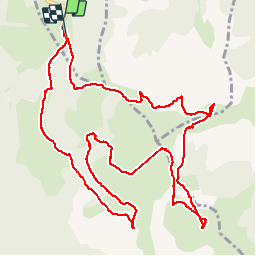

Length
14.9 km

Max alt
1983 m

Uphill gradient
448 m
Km-Effort
21 km

Min alt
1723 m

Downhill gradient
439 m
Boucle
Yes
Creation date :
2019-07-16 08:24:34.622
Updated on :
2019-07-16 12:33:39.249
3h16
Difficulty : Medium

FREE GPS app for hiking
 SityTrail
IGN / Geographical institutes
SityTrail Plus
The world is yours!
About
Trail Walking of 14.9 km to be discovered at Occitania, Ariège, Albiès. This trail is proposed by maupassant38.
Positioning
Country:
France
Region :
Occitania
Department/Province :
Ariège
Municipality :
Albiès
Location:
Unknown
Start:(Dec)
Start:(UTM)
392791 ; 4731167 (31T) N.
Comments