


archiane valcroissant par les 4 chemins

planets
User
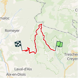

Length
21 km

Max alt
1971 m

Uphill gradient
1396 m
Km-Effort
40 km

Min alt
661 m

Downhill gradient
1493 m
Boucle
No
Creation date :
2019-06-24 07:23:38.155
Updated on :
2019-07-16 19:18:44.949
10h49
Difficulty : Difficult

FREE GPS app for hiking
 SityTrail
IGN / Geographical institutes
SityTrail Plus
The world is yours!
About
Trail Walking of 21 km to be discovered at Auvergne-Rhône-Alpes, Drôme, Châtillon-en-Diois. This trail is proposed by planets.
Positioning
Country:
France
Region :
Auvergne-Rhône-Alpes
Department/Province :
Drôme
Municipality :
Châtillon-en-Diois
Location:
Treschenu-Creyers
Start:(Dec)
Start:(UTM)
698429 ; 4957748 (31T) N.
Comments