


Chemin des lièvres

griffet
User

Length
3.5 km

Max alt
1908 m

Uphill gradient
182 m
Km-Effort
5.9 km

Min alt
1713 m

Downhill gradient
183 m
Boucle
Yes
Creation date :
2019-07-17 12:01:04.0
Updated on :
2019-07-17 21:54:45.879
2h23
Difficulty : Medium

FREE GPS app for hiking
 SityTrail
IGN / Geographical institutes
SityTrail Plus
The world is yours!
About
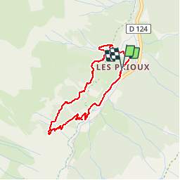
Trail Walking of 3.5 km to be discovered at Auvergne-Rhône-Alpes, Savoy, Pralognan-la-Vanoise. This trail is proposed by griffet.
Description
Facile pour tout le monde
Positioning
Country:
France
Region :
Auvergne-Rhône-Alpes
Department/Province :
Savoy
Municipality :
Pralognan-la-Vanoise
Location:
Unknown
Start:(Dec)
Start:(UTM)
319967 ; 5024139 (32T) N.
Comments