


refuge des bans

sergio19
User
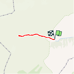

Length
8.5 km

Max alt
2087 m

Uphill gradient
480 m
Km-Effort
14.9 km

Min alt
1612 m

Downhill gradient
479 m
Boucle
Yes
Creation date :
2019-07-17 08:50:56.704
Updated on :
2019-07-18 08:31:49.594
4h06
Difficulty : Medium

FREE GPS app for hiking
 SityTrail
IGN / Geographical institutes
SityTrail Plus
The world is yours!
About
Trail Walking of 8.5 km to be discovered at Provence-Alpes-Côte d'Azur, Hautes-Alpes, Vallouise-Pelvoux. This trail is proposed by sergio19.
Description
Paysage
Positioning
Country:
France
Region :
Provence-Alpes-Côte d'Azur
Department/Province :
Hautes-Alpes
Municipality :
Vallouise-Pelvoux
Location:
Vallouise
Start:(Dec)
Start:(UTM)
294640 ; 4967470 (32T) N.
Comments