Trail Walking Allos - 
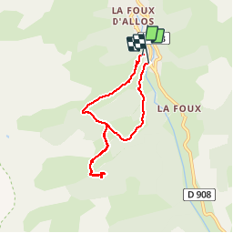
le lac des Grenouilles - Photo
© OpenStreetMap contributors
Length
Length
6.8 km
Max alt
Max alt
2027 m
Uphill gradient
Uphill gradient
299 m
Km-Effort
Km-Effort  
10.8 km
Min alt
Min alt
1746 m
Downhill gradient
Downhill gradient
319 m
Boucle
Boucle
Yes
Creation date :
2014-12-10 00:00:00.0
Updated on :
2014-12-10 00:00:00.0

(0 Reviews)

Walking
Walking
2h30
Difficulty : Easy

Scan this QR Code to open this trail in the SityTrail application

FREE GPS app for hiking

Logo SityTrail SityTrail

IGN / Geographical institutes

Download SityTrail from the App Store Download SityTrail from Google Play

Logo SityTrail SityTrail Plus

The world is yours!

Download SityTrail from the App Store Download SityTrail from Google Play Download SityTrail on Huawei AppGallery

About

Trail Walking of 6.8 km to be discovered at Provence-Alpes-Côte d'Azur, Alpes-de-Haute-Provence, Allos. This trail is proposed by perrinfabrice.

Description

Petite randonnée familiale. Départ depuis le télésiège "Le pont de l'Abrau" et retour au même point avec descente par le "sentier nature". Magnifique paysage avec nombreuses prairies et des forêts de mélèzes. Randonnée réalisable avec enfants à partir de 5-6 ans.

Elevation profile

Positioning

Country:
France
Region :
Provence-Alpes-Côte d'Azur
Department/Province :
Alpes-de-Haute-Provence
Municipality :
Allos
Location:
Unknown
Start:(UTM)
306176 ; 4906380 (32T) N.


Close
My subscriptions