


Tour Longemer - Lispach

micheldutilleul
User
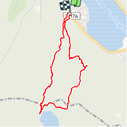

Length
4.1 km

Max alt
1011 m

Uphill gradient
268 m
Km-Effort
7.7 km

Min alt
747 m

Downhill gradient
271 m
Boucle
Yes
Creation date :
2019-07-19 07:36:57.971
Updated on :
2019-07-19 10:14:49.072
2h10
Difficulty : Medium

FREE GPS app for hiking
 SityTrail
IGN / Geographical institutes
SityTrail Plus
The world is yours!
About
Trail Walking of 4.1 km to be discovered at Grand Est, Vosges, Xonrupt-Longemer. This trail is proposed by micheldutilleul.
Positioning
Country:
France
Region :
Grand Est
Department/Province :
Vosges
Municipality :
Xonrupt-Longemer
Location:
Unknown
Start:(Dec)
Start:(UTM)
347130 ; 5325868 (32U) N.
Comments