


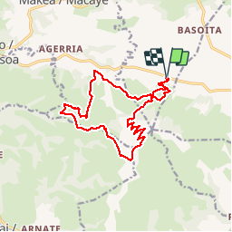
le mont baïgura

phiphidechagny
User

Length
16.6 km
Boucle
Yes
Creation date :
2019-07-20 07:15:51.533
Updated on :
2019-07-20 11:47:40.142
4h30
Difficulty : Medium

FREE GPS app for hiking
 SityTrail
IGN / Geographical institutes
SityTrail Plus
The world is yours!
About
Trail Walking of 16.6 km to be discovered at New Aquitaine, Pyrénées-Atlantiques, Mendionde. This trail is proposed by phiphidechagny.
Description
superbe randonnée sauvage raide ...des montées des descentes du dénivelé des bestioles. bonne condition physique
Photos


26 photos in total. Please click on a photo to see them all in the gallery.
Positioning
Country:
France
Region :
New Aquitaine
Department/Province :
Pyrénées-Atlantiques
Municipality :
Mendionde
Location:
Unknown
Start:(Dec)
Start:(UTM)
639254 ; 4796590 (30T) N.
Comments