


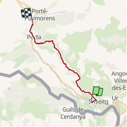
Latour de carol-Puymorens

c.chehere
User

Length
16.4 km

Max alt
2296 m

Uphill gradient
1119 m
Km-Effort
30 km

Min alt
1237 m

Downhill gradient
791 m
Boucle
No
Creation date :
2019-07-21 08:39:42.749
Updated on :
2019-07-21 08:53:40.962
6h16
Difficulty : Difficult

FREE GPS app for hiking
 SityTrail
IGN / Geographical institutes
SityTrail Plus
The world is yours!
About
Trail Walking of 16.4 km to be discovered at Occitania, Pyrénées-Orientales, Enveitg. This trail is proposed by c.chehere.
Description
De la gare de Latour de Carol à l'arrêt de Porté Puymorens pas le col de l'homme mort.
Pas de guichet à l'arrêt Porté-Puymorens
Positioning
Country:
France
Region :
Occitania
Department/Province :
Pyrénées-Orientales
Municipality :
Enveitg
Location:
Unknown
Start:(Dec)
Start:(UTM)
409953 ; 4701328 (31T) N.
Comments