


Pic de Tarbésou - Les Étangs de Rabassolles

maupassant38
User
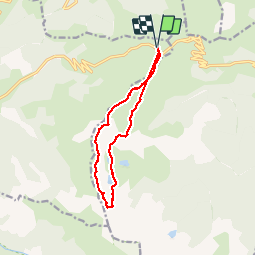

Length
12.2 km

Max alt
2351 m

Uphill gradient
726 m
Km-Effort
22 km

Min alt
1927 m

Downhill gradient
726 m
Boucle
Yes
Creation date :
2019-07-21 07:52:13.372
Updated on :
2019-07-23 16:22:40.802
4h23
Difficulty : Medium

FREE GPS app for hiking
 SityTrail
IGN / Geographical institutes
SityTrail Plus
The world is yours!
About
Trail Walking of 12.2 km to be discovered at Occitania, Ariège, Ascou. This trail is proposed by maupassant38.
Positioning
Country:
France
Region :
Occitania
Department/Province :
Ariège
Municipality :
Ascou
Location:
Unknown
Start:(Dec)
Start:(UTM)
417123 ; 4731665 (31T) N.
Comments