


sabine

petit-pied
User
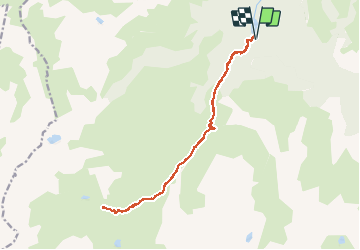

Length
17.6 km

Max alt
1916 m

Uphill gradient
942 m
Km-Effort
30 km

Min alt
1095 m

Downhill gradient
943 m
Boucle
Yes
Creation date :
2019-07-14 07:32:34.268
Updated on :
2019-07-22 06:13:56.352
7h53
Difficulty : Easy

FREE GPS app for hiking
 SityTrail
IGN / Geographical institutes
SityTrail Plus
The world is yours!
About
Trail Walking of 17.6 km to be discovered at Occitania, Ariège, Aston. This trail is proposed by petit-pied.
Positioning
Country:
France
Region :
Occitania
Department/Province :
Ariège
Municipality :
Aston
Location:
Unknown
Start:(Dec)
Start:(UTM)
390639 ; 4728923 (31T) N.
Comments