


Le refuge de l'étendard

Gegetop
User

Length
8.8 km

Max alt
2528 m

Uphill gradient
491 m
Km-Effort
15.4 km

Min alt
2056 m

Downhill gradient
486 m
Boucle
Yes
Creation date :
2019-07-11 08:42:34.646
Updated on :
2019-07-22 07:30:29.969
3h24
Difficulty : Medium

FREE GPS app for hiking
 SityTrail
IGN / Geographical institutes
SityTrail Plus
The world is yours!
About
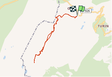
Trail Nordic walking of 8.8 km to be discovered at Auvergne-Rhône-Alpes, Savoy, Saint-Sorlin-d'Arves. This trail is proposed by Gegetop.
Description
Aller et retour en partant du col de la croix de fer.
Photos


Positioning
Country:
France
Region :
Auvergne-Rhône-Alpes
Department/Province :
Savoy
Municipality :
Saint-Sorlin-d'Arves
Location:
Unknown
Start:(Dec)
Start:(UTM)
280369 ; 5012032 (32T) N.
Comments