


Source de la vachère

Gegetop
User
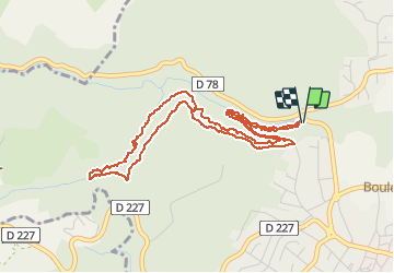

Length
5.9 km

Max alt
566 m

Uphill gradient
175 m
Km-Effort
8.2 km

Min alt
437 m

Downhill gradient
175 m
Boucle
Yes
Creation date :
2019-07-18 11:36:42.865
Updated on :
2019-07-22 07:30:31.697
1h20
Difficulty : Easy

FREE GPS app for hiking
 SityTrail
IGN / Geographical institutes
SityTrail Plus
The world is yours!
About
Trail Walking of 5.9 km to be discovered at Auvergne-Rhône-Alpes, Puy-de-Dôme, Châtel-Guyon. This trail is proposed by Gegetop.
Description
Départ vallée des Prades
Positioning
Country:
France
Region :
Auvergne-Rhône-Alpes
Department/Province :
Puy-de-Dôme
Municipality :
Châtel-Guyon
Location:
Unknown
Start:(Dec)
Start:(UTM)
504871 ; 5086358 (31T) N.
Comments