


Refuge des Étangs de Bassiès

maupassant38
User
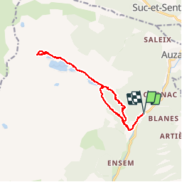

Length
16.7 km

Max alt
1681 m

Uphill gradient
961 m
Km-Effort
29 km

Min alt
828 m

Downhill gradient
959 m
Boucle
Yes
Creation date :
2019-07-22 08:09:18.844
Updated on :
2019-07-23 15:42:08.191
5h15
Difficulty : Medium

FREE GPS app for hiking
 SityTrail
IGN / Geographical institutes
SityTrail Plus
The world is yours!
About
Trail Walking of 16.7 km to be discovered at Occitania, Ariège, Auzat. This trail is proposed by maupassant38.
Positioning
Country:
France
Region :
Occitania
Department/Province :
Ariège
Municipality :
Auzat
Location:
Unknown
Start:(Dec)
Start:(UTM)
374354 ; 4733574 (31T) N.
Comments