


badonviller Pierre percée barrage

raline
User GUIDE
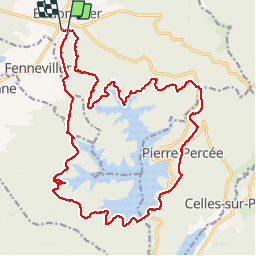

Length
22 km

Max alt
495 m

Uphill gradient
493 m
Km-Effort
28 km

Min alt
312 m

Downhill gradient
490 m
Boucle
Yes
Creation date :
2019-07-23 07:45:10.126
Updated on :
2019-07-23 12:38:29.113
4h52
Difficulty : Very easy

FREE GPS app for hiking
 SityTrail
IGN / Geographical institutes
SityTrail Plus
The world is yours!
About
Trail Horseback riding of 22 km to be discovered at Grand Est, Meurthe-et-Moselle, Badonviller. This trail is proposed by raline.
Positioning
Country:
France
Region :
Grand Est
Department/Province :
Meurthe-et-Moselle
Municipality :
Badonviller
Location:
Unknown
Start:(Dec)
Start:(UTM)
344337 ; 5373603 (32U) N.
Comments