Trail Walking Bouzemont - Circuit de la Madonne et Lamerey - Photo

Circuit de la Madonne et Lamerey

 tracegps
tracegps

User

© OpenStreetMap contributors
Length
Length
9.5 km
Max alt
Max alt
438 m
Uphill gradient
Uphill gradient
182 m
Km-Effort
Km-Effort  
11.9 km
Min alt
Min alt
298 m
Downhill gradient
Downhill gradient
181 m
Boucle
Boucle
Yes
Creation date :
2014-12-10 00:00:00.0
Updated on :
2014-12-10 00:00:00.0

(0 Reviews)

Walking
Walking
1h19
Difficulty : Easy

Scan this QR Code to open this trail in the SityTrail application

FREE GPS app for hiking

Logo SityTrail SityTrail

IGN / Geographical institutes

Download SityTrail from the App Store Download SityTrail from Google Play

Logo SityTrail SityTrail World

The world is yours!

Download SityTrail from the App Store Download SityTrail from Google Play Download SityTrail on Huawei AppGallery

About

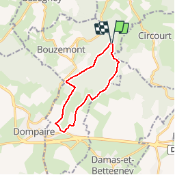
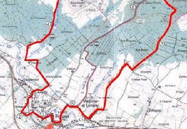
Trail Walking of 9.5 km to be discovered at Grand Est, Vosges, Bouzemont. This trail is proposed by tracegps.

Description

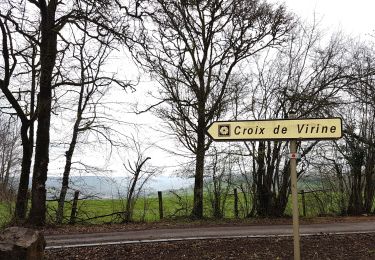
Dans Lamerey, on emprunte la belle artère de la rue du Haut Fays, bordée des fermes lorraines. Le circuit emprunte un chemin de Bouzemont. La voie Saint-Pierre monte sur le relief du bois du Haut Fays pour un circuit de 10 km.

Elevation profile

Photos

Positioning

Country:
France
Region :
Grand Est
Department/Province :
Vosges
Municipality :
Bouzemont
Location:
Unknown
Start:(UTM)
296757 ; 5347890 (32U) N.

Trails nearby

Trail On foot Bouxières-aux-Bois - Circuit des Fontaines et Lavoirs - Photo
On foot
GUIDE+

On foot

Easy
Bouxières-aux-Bois, Grand Est, Vosges, France
15 km | 18.8 km-effort
4h 15min
Yes
Trail On foot Derbamont - Circuit des Deux Vallons - Photo
On foot
GUIDE+

On foot

Easy
Derbamont, Grand Est, Vosges, France
12.3 km | 15.8 km-effort
3h 36min
Yes
Trail Walking Circourt - Circourt - Photo
Walking
triburemy

Walking

Difficult
Circourt, Grand Est, Vosges, France
7.4 km | 10 km-effort
1h 53min
Yes
Trail Walking Bouxières-aux-Bois - Bouxieres-aux-bois : Le circuit de Virine - Photo
Walking
ABICHE

Walking

Very easy
Bouxières-aux-Bois, Grand Est, Vosges, France
14.2 km | 18.3 km-effort
5h 7min
Yes
Trail Walking Mazeley - chanot  - Photo
Walking
ACPL

Walking

Medium
Mazeley, Grand Est, Vosges, France
9.8 km | 11 km-effort
4h 25min
No
Trail Walking Bouzemont - Circuit de Bouzemont - Dompaire - Photo
Walking
tracegps

Walking

Difficult
Bouzemont, Grand Est, Vosges, France
14 km | 17.2 km-effort
3h 30min
Yes
Trail Walking Circourt - Circuit de Virine - Circourt - Photo
Walking
tracegps

Walking

Medium
Circourt, Grand Est, Vosges, France
13.6 km | 17.6 km-effort
3h 0min
Yes
Trail Walking Dompaire - Circuit de Dompaire - Photo
Walking
tracegps

Walking

Medium
Dompaire, Grand Est, Vosges, France
14.6 km | 18.1 km-effort
3h 0min
Yes
Trail Walking Circourt - Circuit de Circourt - Photo
Walking
tracegps

Walking

Easy
Circourt, Grand Est, Vosges, France
5.8 km | 7.7 km-effort
1h 0min
Yes


Close
My subscriptions