


eygoires boscodon retour route

guariso
User

Length
21 km

Max alt
1110 m

Uphill gradient
563 m
Km-Effort
29 km

Min alt
775 m

Downhill gradient
564 m
Boucle
Yes
Creation date :
2019-07-24 07:31:42.669
Updated on :
2019-07-24 09:55:36.047
2h20
Difficulty : Easy

FREE GPS app for hiking
 SityTrail
IGN / Geographical institutes
SityTrail Plus
The world is yours!
About
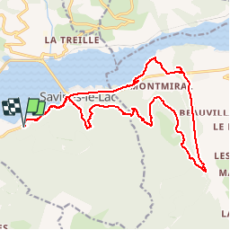
Trail Mountain bike of 21 km to be discovered at Provence-Alpes-Côte d'Azur, Hautes-Alpes, Savines-le-Lac. This trail is proposed by guariso.
Description
pas de difficulté
retour par route...
Positioning
Country:
France
Region :
Provence-Alpes-Côte d'Azur
Department/Province :
Hautes-Alpes
Municipality :
Savines-le-Lac
Location:
Unknown
Start:(Dec)
Start:(UTM)
292120 ; 4932650 (32T) N.
Comments