


Tara

Arnaud Dejean
User

Length
8.3 km

Max alt
698 m

Uphill gradient
151 m
Km-Effort
10.5 km

Min alt
595 m

Downhill gradient
187 m
Boucle
No
Creation date :
2019-07-24 08:50:26.528
Updated on :
2019-07-24 13:23:48.393
2h07
Difficulty : Very easy

FREE GPS app for hiking
 SityTrail
IGN / Geographical institutes
SityTrail Plus
The world is yours!
About
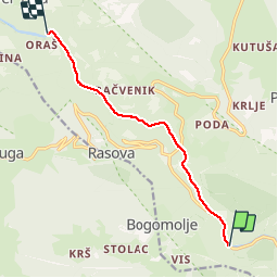
Trail Canoe - kayak of 8.3 km to be discovered at Unknown, Pljevlja Municipality. This trail is proposed by Arnaud Dejean.
Positioning
Country:
Montenegro
Region :
Unknown
Department/Province :
Pljevlja Municipality
Municipality :
Unknown
Location:
Unknown
Start:(Dec)
Start:(UTM)
362605 ; 4776401 (34T) N.
Comments