


Saint-Hubert 25 juillet 19

pierlan
User
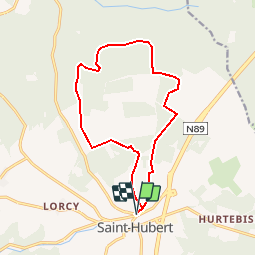

Length
13.1 km

Max alt
582 m

Uphill gradient
329 m
Km-Effort
17.5 km

Min alt
421 m

Downhill gradient
328 m
Boucle
Yes
Creation date :
2019-07-24 17:00:11.722
Updated on :
2019-07-24 17:01:12.194
3h43
Difficulty : Difficult

FREE GPS app for hiking
 SityTrail
IGN / Geographical institutes
SityTrail Plus
The world is yours!
About
Trail Walking of 13.1 km to be discovered at Wallonia, Luxembourg, Saint-Hubert. This trail is proposed by pierlan.
Positioning
Country:
Belgium
Region :
Wallonia
Department/Province :
Luxembourg
Municipality :
Saint-Hubert
Location:
Saint-Hubert
Start:(Dec)
Start:(UTM)
670057 ; 5544444 (31U) N.
Comments