


Mont Vinaigre

Spinnaker
User

Length
6.5 km

Max alt
196 m

Uphill gradient
189 m
Km-Effort
9.3 km

Min alt
0 m

Downhill gradient
280 m
Boucle
No
Creation date :
2019-07-25 08:04:15.541
Updated on :
2019-07-25 10:01:06.931
1h55
Difficulty : Easy

FREE GPS app for hiking
 SityTrail
IGN / Geographical institutes
SityTrail Plus
The world is yours!
About
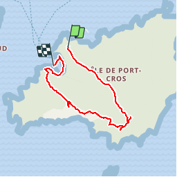
Trail Walking of 6.5 km to be discovered at Provence-Alpes-Côte d'Azur, Var, Hyères. This trail is proposed by Spinnaker.
Positioning
Country:
France
Region :
Provence-Alpes-Côte d'Azur
Department/Province :
Var
Municipality :
Hyères
Location:
Unknown
Start:(Dec)
Start:(UTM)
286869 ; 4765400 (32T) N.
Comments