


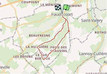
La Huanière (N° 5) - Haudricourt

tracegps
User


2h40
Difficulty : Medium

FREE GPS app for hiking
 SityTrail
IGN / Geographical institutes
SityTrail Plus
The world is yours!
About
Trail Walking of 10.6 km to be discovered at Normandy, Seine-Maritime, Haudricourt. This trail is proposed by tracegps.
Description
Circuit proposé par l'Office de Tourisme d'Aumale. Au départ de l'église d'Haudricourt, direction vers le hameau de St Ouen, prendre la direction du bois de la Vergne. Faire 2 épingles à cheveux pour prendre la direction de la ferme Frévent. Suivre le circuit jusqu'au 1er carrefour que l'on continue tout droit. Tourner à droite pour passer devant la ferme du Clos Bertaux, tourner à droite avant la Huanière en direction du bois d'Haudricourt. Une fois à Haudricourt-au-Bois, rejoindre St Ouen et revenir par le même chemin au départ.
Photos
 - Haudricourt - Photo 1")
 - Haudricourt - Photo 2")
 - Haudricourt - Photo 3")
 - Haudricourt - Photo 4")
 - Haudricourt - Photo 5")
 - Haudricourt - Photo 6")
Positioning
Comments