Zabljak: circuit point de vue Curevac

suntajl
User
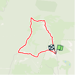

Length
3.3 km

Max alt
1618 m

Uphill gradient
115 m
Km-Effort
4.8 km

Min alt
1502 m

Downhill gradient
115 m
Boucle
Yes
Creation date :
2019-07-27 15:23:27.043
Updated on :
2019-11-10 09:55:12.34
1h30
Difficulty : Medium

FREE GPS app for hiking
 SityTrail
IGN / Geographical institutes
SityTrail Plus
The world is yours!
About
Trail Walking of 3.3 km to be discovered at Unknown, Žabljak Municipality. This trail is proposed by suntajl.
Description
La partie crête (parties nord et ouest) n'est pas facile et rocheuse mais très belle, le reste est facile. Parking plus vaste et café au point extrême sud-ouest . Petite route entre les 2 parkings.
Positioning
Country:
Montenegro
Region :
Unknown
Department/Province :
Žabljak Municipality
Municipality :
Unknown
Location:
Unknown
Start:(Dec)
Start:(UTM)
345650 ; 4784062 (34T) N.
Comments