


villemandeur

lemuid
User
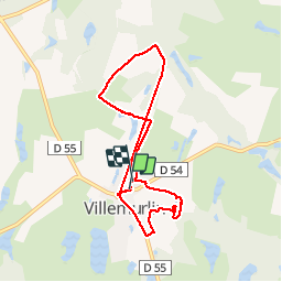

Length
7.4 km

Max alt
141 m

Uphill gradient
35 m
Km-Effort
7.8 km

Min alt
129 m

Downhill gradient
37 m
Boucle
Yes
Creation date :
2019-07-28 07:46:26.99
Updated on :
2019-07-29 06:10:26.716
1h47
Difficulty : Very easy

FREE GPS app for hiking
 SityTrail
IGN / Geographical institutes
SityTrail Plus
The world is yours!
About
Trail Walking of 7.4 km to be discovered at Centre-Loire Valley, Loiret, Villemurlin. This trail is proposed by lemuid.
Positioning
Country:
France
Region :
Centre-Loire Valley
Department/Province :
Loiret
Municipality :
Villemurlin
Location:
Unknown
Start:(Dec)
Start:(UTM)
450157 ; 5281668 (31T) N.
Comments